|
Moses Looney Fort (Revisited)
by W. Dale Carter, copyright 1997
The late Gordon Aronhime published a pamphlet in 1980 that placed the location of Moses Looney's Fort on the island road one mile east of the intersection of the island road and Tennessee State Route no. 1 on the head waters of fall creek. This location is in error. Aronhime based his theory on the location of Looney's Fort on two sources: John Anderson's manuscript and on a Tennessee land grant recorded in Sullivan County deed book 19 page 409.
The Anderson manuscript states that the Anderson family was at Looney's Fort when the army commanded by Col. Christian passed by the fort on its way to engage the Indians of the Cherokee nation. From this information Aronhime concluded that Moses Looney's fort was located on the island road.
Court records provide the following:
Fincastle County, Virginia court record dated 6 Jan 1773 orders that David Steel be appointed surveyor of the road from steel creek to muddy creek and that Moses Looney be appointed surveyor of the road from muddy creek to the county line.
Washington County, Virginia court records dated 29 Jan 1777 orders David Steel be surveyor of the main road from steel creek to the meeting house and that Amos Eaton be surveyor of the main road from the meeting house to Fort Patrick Henry.
Washington County, Virginia court record dated 30 Sep 1777 orders Moses Looney and John Anderson to view the road from Brice Russells to the main road at the meeting house said road to be cut at the expense of Brice Russell.
Court appointed surveyor of roads responsibility was to keep the roads in good repair. They were prominent property owners and the roads they were responsible for ran through their property. In 1777 David Steel was surveyor of the road from steel creek to the meeting house. His property lay on both sides of old U S 11W between Bristol and Blountville, therefore the main road in 1777 must have followed approximately the same route it now does Bristol to Blountville and thence to the meeting house at the Gunnings community.
No doubt Col. Christian passed by Looney's Fort in July of 1776 on his way to the Cherokee expedition and he traveled the only maintained road in the area, the main road from Bristol to Blountville to Gunnings. No record has been found that the island road was a maintained road in 1777.
Mr. Aronhime made a search along the island road "until a complex of sufficient antiquity could be spotted and the likeliest prospect turned out to be the home of Mr. Charles Pope Sr”. Mr. Aronhime traced this land back to a Tennessee land grant recorded in Deed Book 19, page 409. If one compares this Tennessee grant to James Anderson's North Carolina grant No. 573 recorded in Deed Book 2, page 694, you will find they are almost identical. Moses Looney never owned the land on which the Pope home is located.
The question remains, where was Moses Looney's home or fort located?
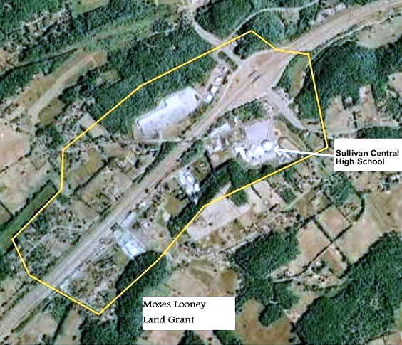
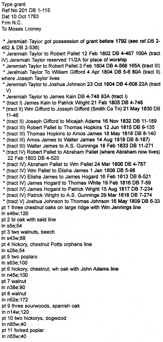
Moses Looney was an inhabitant of Sullivan County, North Carolina as early as 1773, and in 1782 he obtained a grant No. 201 from North Carolina for 383 acres. This grant was recorded in Deed Book 1, page 115, it being the only entry of a land transaction by him. There is no record in Blountville as to how he disposed of this land; therefore, the land could not be traced by the usual grantor-grantee process. Since these North Carolina land grants were fairly descriptive as to general location, adjoining property owners and the actual survey giving bearings and distances, a plot of the survey was made to the same scale as the U.S. geological survey maps. All the surrounding grants were also plotted and fitted together like one giant jigsaw puzzle. The composite of these plots were overlaid on a USGS geological map. Survey points as described in the original surveys were matched with points on the map that could be identified. The trick was to locate a point that would remain unchanged after 200 years, such as bank of river; top of a ridge; gap of a knob; or head of a spring. Fortunately, Moses Looney's grant stated that his grant adjoined the land of William Jennings, John Adams, Ann Palate, and Daniel Duggin, and by fitting these grants together and building on them with other grants gave a large area to work with. When this composite was overlaid on a map, the only location that matched the survey descriptions placed the Moses Looney grant at the intersection of Interstate 81 and old Highway11W at Gunnings. In fact, Sullivan Central high school sits on the Moses Looney grant.

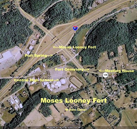
Next, the land Sullivan Central High School sits on was traced back to Jeremiah Taylor. By some means which has yet to be resolved, Jeremiah Taylor came into possession of Looney's grant before 1792 and sold it off in five tracts between 1802 and 1805. These five tracts were plotted and they fit almost perfectly within the boundaries of Moses Looney's grant. The land Sullivan Central High School sits on was sold to Robert Pallet and 1-1/2 acres was reserved for a place of worship. This church known as the Taylor meetinghouse is the oldest church in the state of Tennessee. The old section of the Gunnings Cemetery is also located on the 1-1/2 acre tract.
A North Carolina land grant was issued to Ann Palate 9 Aug 1787 based on an entry No 643, entered 10 Jul 1780 and issued 29 Jan 1782 to include head of spring above Looney's old fort. The Palate grant joined the Looney grant on the north side.

I have studied the Looney grant as to contour of land, location of roads, and water supply and have concluded the most likely location of a home or fort would be approximately 200 feet west of old Highway 11W and almost in the center of Interstate Highway no. 81.This location is close to a large free flowing spring and on a slight knoll that drains well. Furthermore, the road to Fort Patrick Henry and the road to Greenville, Shipley Ferry road, intersect nearby. The meeting house was located less than 1000 feet to the east. This is a central location for the neighboring residents, and one could understand that it was a logical place for the residents to assemble.
It would be proper and fitting that a historical marker be placed at the site of the fort.

| 